Leave the moment it shakes: Chilean study maps the safest tsunami escape routes
Two Chilean researchers combined 119 GPS tracks from residents and students in tsunami drills in Viña del Mar (2022-2026) with a flood model. Leaving straight away, 100 of the 119 would have reached safety; leaving after 8 minutes, 49; after 12 minutes, just 3. The method is cheap and shows which streets work. It covers one city and mostly university students, though it can be repeated on other coasts.
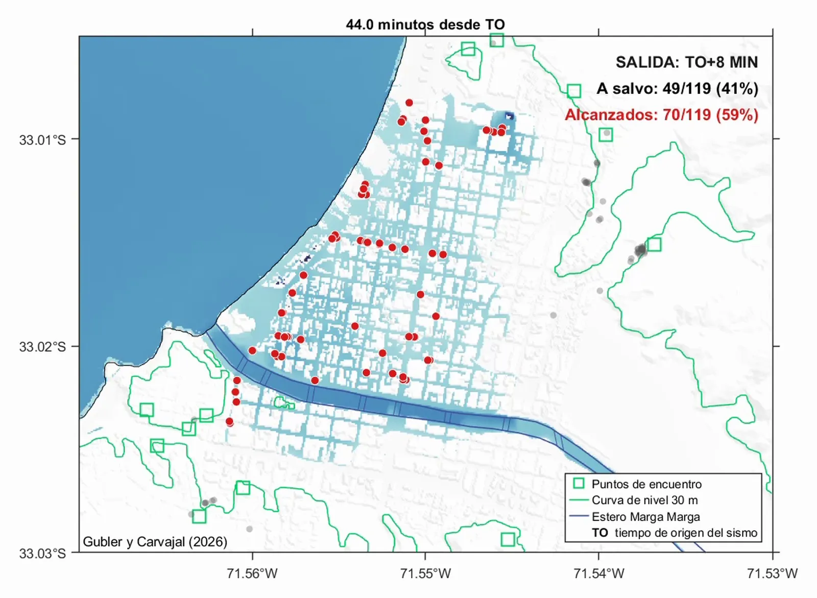
One hundred out of 119. That is how many residents and students in Viña del Mar, Chile, would have reached safety from a tsunami if they had started walking straight after the earthquake. Had they waited eight minutes, only 49 would have. With a twelve-minute delay, three.
The figures come from a study by Alejandra Gubler and Matías Carvajal, of the Pontifical Catholic University of Valparaíso and the Pontifical Catholic University of Chile, published in Seismological Research Letters. Between 2022 and 2026 they recorded the GPS routes of people taking part in the city’s evacuation drills and combined them with a model of how the water would advance.
Two streets 200 metres apart, two very different outcomes
The researchers grouped the 119 routes into 13 main corridors. The later people leave, the fewer corridors still work, and they do not all fail at once:
- Leaving after eight minutes, 91% of people in one corridor would have made it, against 13% in another just 200 metres away.
- The study’s animations show each participant as a dot that turns red where the simulated water reaches them.
“Most of the tools communities rely on, such as evacuation maps, are static,” Gubler says in the Seismological Society of America’s release. Her method adds time: not just where to go, but how long each route stays safe.
A low-cost tool other coasts can use
The system relies on GPS data from drills that already happen and on existing flood models, so it is cheap to run. The authors believe it can help residents and officials decide which streets to improve, and persuade people not to wait.
According to Gubler, what affects participants most is seeing their own route in the animation: “watching your own is what really makes an impression.”
The study covers one city and volunteers who were mostly university students, and the results depend on the simulated earthquake. The core lesson applies to any coast at risk of tsunamis, and Gubler puts it simply: the safety margin is very small, “so every minute really counts.” The paper is part of an upcoming special section of the journal on emergency response.